a![]()
Tornado-genesis by an
Isentropic Energy Transformation
(June
2008)
Summary:
![Text Box: V = [2cpΔT(ΔT/T)]1/2
(Heat engine)
V = n1/2co ( ΔT/T)1/2
(Isentropic)](Energy%20Compressibility%20Part%20II;%20Tornado%20genesis_files/image002.png) Analysis of a very simple, rare whirlwind
occurring over cool lake surfaces indicates that an isentropic transformation
of heat energy into the kinetic energy of wind speed occurs.
Analysis of a very simple, rare whirlwind
occurring over cool lake surfaces indicates that an isentropic transformation
of heat energy into the kinetic energy of wind speed occurs.
The same transformation can explain the initial high wind speeds observed in tornadoes at their formation, where a heat engine explanation fails completely.
Contents
1. Introduction
2. Vortex Motions
3. Is the Tornado a Heat Engine?
4.
Waterspouts and Dust Devils as Heat Engines
5. Fine Weather
“Cool-lake Whirlwinds”(CLW)
6. An Alternative Explanation: Isentropic, Adiabatic Flow Transformations in Vortex Flow
7. A Possible New Insight into Tornado-genesis at
Temperatures Inversions Aloft
8. Insights into Potential Tornado Modification or “ Control”
9. Conclusions
References
 1. Introduction
Tornados, waterspouts and dust devils are sometimes considered to be atmospheric heat engines, transforming heat energy differences (Δ Q, ΔT) between a heat source of higher temperature in the air at the earth’s surface and a heat sink region of lower temperature aloft, into kinetic energy ½ mV2 and into wind flow V and work W.
However, the initial formation of these atmospheric whirlwinds in regions initially of small temperature differences means a very small thermodynamic heat engine efficiency and very small wind speeds, and this conflicts with the quite sudden appearance of high winds. Some theories have attempted an explanation by introducing additional sources of energy other than heat, such as lightning stokes, into the vortex core [1,2] to account for this discrepancy.
Current research has concentrated, instead, on a greatly improved understanding of the many complex dynamic details of these violent storms provided by the availability of such tools as Doppler radar to measure internal wind speeds in the vortices, and on numerical simulation to model a wide range of flow possibilities. Once fully formed, these complicated violent storms are now fairly well understood [3] but the early stage mechanism is not.
Here, we shall examine a very rare, extremely simple, yet violent atmospheric whirlwind which occurs under weather conditions which are apparently completely the opposite to those in other whirlwinds. Tornados and waterspouts form over warm surfaces in windy cloudy weather. This rare whirlwind forms over cool lakes under fine, sunny, calm conditions, with the vortex arising suddenly and violently in a very small area while all else around remains undisturbed. We shall call these special vortices “ cool-lake whirlwinds’ ( (CLW) for want of a better name, and see if their extremely simple structure may offer clues to understanding the more violent and complicated storms such as tornadoes and waterspouts.
2. Vortex Motions
A Vortex involves organized circulatory or rotary motion of a fluid (i.e. liquid or gas) in which the fluid motion is round and round about a central point or central axis. The swirling motion of water slowly draining from a sink or wash basin is an example of a vortex. The flow around the perimeter of the basin and in the main body of the water in the wash basin is circulating, but it is not technically rotating. This seems a bit contradictory, but, for example, a floating cork which has a straight index line inscribed on its top, circulates around and round with the water, but the orientation of the line inscribed on the cork acts much as the needle of a compass and remains pointing in the same direction.. While the cork and the water it is floating in certainly do circulate, they do not themselves rotate. However in the very centre of the swirling water, if there is no actual gap in the fluid, the motion is different ---there the water core rotates in a wheel-like manner so that the rotation becomes zero at the central axis.
When the flow is steady, the outer, non-rotating circulation is described mathematically as
VT r = Γ =constant
were Γ with dimensions of angular momentum is called the circulation, VT is the velocity at any point of radius r. An example of this type of circulatory motion is the potential vortex, often called a free vortex, in which the motion can be described by a potential velocity function φ, such that dφ/dx = V [4,5,6].
The true rotational motion in the inner core is called solid or wheel-like rotation, or sometimes a forced vortex or rectilinear vortex, and is described mathematically as
VT/r = ω
were ω is the rotation with the dimensions of frequency.
Atmospheric vortices typically consist of an outer
circulatory whirl of irrotational or potential motion) enclosing a very
small inner core of solid rotation. The
presence of the solid rotational core is
physically necessary because a pure
circulatory or potential vortex
would require a velocity V of
infinity at the core where r = 0, and
so, in nature, some adjustment is necessary. This problem of infinity is
avoided by a core having solid-like
rotation, since then the velocity drops to zero at the central axis where r = o
as required. The two flow systems 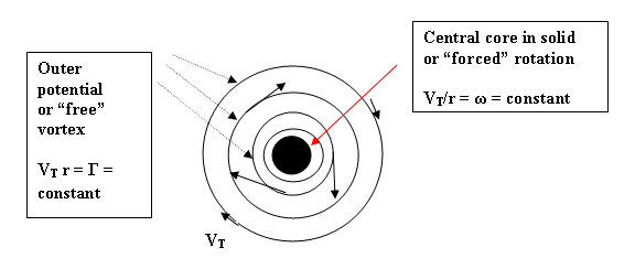 together
are often called a Rankine combined
vortex [4,5,7,8] .
together
are often called a Rankine combined
vortex [4,5,7,8] .
Figure 1 Rankine Combined Vortex.
The classical work on vortex motions in fluids by Helmholtz, as extended to air motions by Rayleigh, is described by Lamb [4] and by Prandtl and Tietjens [5]. In 1934 Brunt {9}applied this vortex theory to explain the structure of hurricanes and tornadoes. For simplicity, Brunt assumed air to be incompressible and postulated the vortex structure to be a Rankine combined vortex , i.e. a forced vortex core, surrounded by a free or potential vortex. This model was then widely used to explain these atmospheric vortices in a general way, but correspondence with the observed details of structure and dynamics was found to be insufficient. For example, to explain the high wind speeds in tornadoes in incompressible theory, a radial inflow into the vortex with conservation of angular momentum had to be postulated. This would explain the spin-up from low speed in the outer region to high tangential wind speeds in the core through conservation of angular momentum ( Vr = Γ =const.) in the radial inflow. However, with inflow, it was also necessary to then postulate an outflow ( at high levels in the atmosphere) in order to keep the process going and avoid “filling up” the vortex. This in turn led research off into the complex details of storm cloud dynamics.
In 1954 Abdullah [10], in an effort to improve on Brunt, applied the theory of compressible air flow to tornadoes which then permits the transformation of internal heat energy into kinetic energy or motion. He postulated that the maximum speed would then be the critical or Mach 1 speed given by V* = [ n/n+1 ]1/2 co. where V* is equal to c*, the sonic speed, at Mach 1 ( approx. 301 m/s for air with n = 5). Here n is the energy partition parameter related to the ratio of specific heats k as n = 2/ k−1, where k = cp/cv..
Vonnegut [1] showed later that the Abdullah sonic velocity limit ( M = 1) could not be reached thermodynamically via a heat engine transformation, given the poor efficiency of such engines and the known temperature differences in the atmosphere between ground and the stratosphere ( about 70˚C versus about 115˚C needed) and so he postulated an input of electrical energy from lighting strikes in the tornado core in order to make the heat engine model work. [Eventually it was determined [7, 15] by observations that tornado speeds at the ground are actually much lower, at around 100 to 130 m/s, and so the energy upgrading hypothesis was not needed].
We now proceed to examine two compressible flow models: first the heat engine model and then an isentropic flow model.
3.0
Is the Tornado a Heat Engine?
The large scale characteristics of the tornado [3] include: (a) Extremely strong swirling ground level wind speeds ranging from about 75 miles per hour ( 33 meters per second) in the weak category (F1), up to over 220 mph ( 100 m/s ) in severe tornadoes (F4), and to over 300 mph ( 130 m/s) in supercell storms (F5).
The earlier idea [1,2,10] that tornado wind speeds at the core were actually sonic ( i.e. about 300 m/s, 670 mph ) led to great difficulties in finding the necessary atmospheric energy source to account for such extreme wind speeds. Later observations [7,16] that the maximum boundary level winds are only about 130 m/s has resulted in models that are much closer to the observations.
(b) The visible, rope- like funnel of the tornado or ‘ twister’, is not the entire swirl of wind, but is only the visible condensed cloud of water droplets which forms when the air in the whirl has expanded and cooled in the lower pressure which prevails towards the center of the funnel until the relative humidity has reached 100% .
(c) The visible funnel cloud emerges from the base of a storm cloud at a height of typically around one or two thousand meters, and the funnel then extends lower and lower towards the earth’s surface. The tip of the funnel may not reach the ground at all, and in such cases it usually retreats back up and disappears into the parent cloud from which it emerged. If the funnel does “ touch down” at the ground, it suddenly broadens in diameter and the swirling winds at the ground speed up. While the tip of the descending funnel may be only a few meters in diameter before touch down, immediately afterwards the base diameter typically becomes 50 to 100 meters across and may increase to over a kilometer in severe tornados.
(d) The general air mass in which the storm forms is always very convectively unstable with warm moist air at the ground and cool air aloft. The parent cloud often is already, or soon becomes, a violent thunderstorm cloud. The most severe storms are called super-cell thunderstorms.
A standard scale of tornado intensities devised by Fujita is
shown in Table 1.
Table 1
Fujita Scale of
Tornado Intensity
F Value Description Wind Speeds
m/s
mph
F0 Light 18-32 m/s 40-72 mph
F1 Moderate 73-112 mph 33-50
F2 Significant 113-157 51-70
F3 Severe 158-206 71-92
F4 Devastating 207-260 93-116
F5* Incredible 261-318 117-142
F6* Inconceivable 319-379 143-170
Note: Lewellen [ 7] writes “ maximum low level velocities are limited to less than 110-130 m/s.” This limitation solves the problem raised by earlier ideas [1,2,10] that maximum tornado winds were near sonic speed [ 300 m/s, 670 mph] . Such speeds placed impossible requirements on the temperature differences ( ΔT ~ 115˚C) needed to explain tornados as heat engines, and as already pointed out above, led Vonnegut and others [1,2] to theorize about lightning strokes in the funnel core providing an additional source of the energy needed for such extreme speeds.
One common explanation of a tornado has been that it is an atmospheric heat engine driven by convective instability between a warm moist source at the ground level and the upper atmospheres at much cooler sink temperatures, the general temperature differential in a mature tornado thus being about 40 - 50°g C. The vorticity, i.e. the swirling or rotating motion is usually described as having originated from wind shear between interacting air streams in the storm system [3].
The heat engine is an irreversible, non-isentropic flow, where the relationship between velocity V, and thermodynamic quantities Q, and T, is given [1,6] by:
V = [ 2 cp ΔT (ΔT/To) ]1/2 (1)
where cp is the specific heat at constant pressure ( 0.244 gram calories in air at 20C), ΔT = To − Ti is the temperature drop from source to sink, and ΔT/To = ( To − T)/To = 1 − T/To is the thermodynamic efficiency of the heat engine as required by the 2nd law of thermodynamics, and which limits the amount of work that can be extracted from any given heat input. ( The work done ( dW = pdv) enters through expansion (dv) of the air in the vortex). Table 2 shows the values of velocity V for given values of temperature difference ΔT computed from Eqn. 1. for atmospheric air.
Table 2
Maximum calculated wind
speeds in the heat engine model (*)
V = [ 2 x 0.244 x 4186 x ΔT x eff. ]1/2 meters per sec.; To = 293˚C
ΔT T Efficiency
[ΔT/T] Tangential
Velocity V
0.5 292.5
0.5/293= 0.0017 1.32 m/s 3.0 mph**
1 292K 1/293
= 0.0034
2.63 5.9
2 291 2/293 = 0.0068
5.3 11.8
3 290 3/293
= 0.01
7.8 17.5
4 289 0.014
10.7 23.9
5 288 0.017
13.1 29.5
6 287 0.02
15.7 35.0
7 286 0.024
18.5 41.2
8 285 0.027
21.0 47.0
9 284 0.031
23.9 53.4
10 283 0.034
26.4 59.0
12 281 0.0.041
31.7 71.0
15 278 0.051
39.5 88.4
20 273 0.068
52.7 117.9
25 268 0.085
65.9 147.4
30 263 0.102
79.1 177
40 253 0.137 105.8 237
50 243 0.17
132 295
70 223 0.238
184 411
100 193 0.34
263.5 590
115 178 0.39 302.7 677
* cp = 0.244 cal /g/˚K= .244 x 4186 = 1021.4 Joules ; ** meters /sec x 2.2369 = mph
Note 1. Values in red are those corresponding to maximum observed temperature differences in the troposphere, that is to maximum wind speeds attainable via the heat engine thermodynamic transformation. Values in blue correspond to the usual small temperature differences existing in the atmosphere when vortices first form.
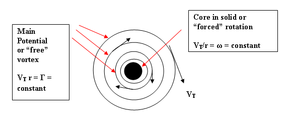
Figure 1. Rankine Combined Vortex
On the assumption that the flow velocities V in Table .1 apply to the tangential velocities VT in the vortex. (Fig.1 above ) it is clear that even weak tornadoes with winds of say 100 mph ( 45 m/s) will require temperature contrasts of about 15 to 20 degrees C to form. These large temperature contrasts are not evident in the initial whirls or funnels that extend down from low lying storm clouds only 2000 to 3000 feet above ground so that the heat engine fails to explain their origin.
The maximum tornadoes from super cells that have vertical convection paths extending from ground level to near the stratosphere do have the temperature contrast from bottom to top (source and sink) of say 50 degrees C, with the ground source inflow having a temperature of say 293 degrees and the cloud tops at say 240 degrees, but this is so only after the tornado cloud is fully grown to its greatest height. The initial funnel reaching down from the parent cloud layer at say 2 to 3 thousand feet above ground, typically has a temperature difference between cloud and ground ΔT of only about 5C degrees or so, and is therefore able by itself to produce funnel winds of only 13 m/s ( 30 mph) under the thermodynamic heat engine restrictions of small efficiency (Table 1) .
Clearly, other sources of energy input must be found, other than purely convective instability temperature contrasts between cloud and ground, to account for the much greater intensity of tornado winds that actually occur. We see from Table 1 that the a heat engine model with the temperature differentials of not more than 3 deg C that are available initially can only account for winds of say 7.8 m/s ( 17.5 mph) instead of the 30+ m/s . The conclusion must be, that, in its initial stages, the tornado is not a heat engine.
Once the funnel touches down at the earth’s surface intensification occurs. The winds increase and the funnel base broadens. The source of this additional input of energy appears related to the infiltration of warm and moist surface air into the vortex as the drag of surface friction unbalances the purely tangential flow and permits a partial radial inflow of surface air. However, even, say, 3˚C warmer air plus 2˚C degrees from additional condensation of water vapour to visible funnel cloud for a total of say , 8˚C will yield only 21 m/s ( 47 mph) velocity versus the 50 -100 m/s observed, which would requiring a temperature differential of from 20 to 40˚C. Again the heat engine hypothesis fails even with addition of energy from condensation of water vapour.
We shall shortly (Section 6) explore a different thermodynamic process than the heat engine, which does yield the observed higher wind speeds in the initial tornado stage. But first, we explore waterspouts, dust devils and a very rare, small whirlwind which occurs in fine weather over cool, calm water surfaces on lake and rivers.
4.0
Waterspouts and Dust Devils as Heat Engines?
Waterspouts [11] have
most of the characteristics of tornadoes except that they occur only over water
and that they are less intense. Typically waterspouts are about the strength of
a category F1 tornado with surface winds of about 75 to 100 mph. They develop
from overhanging cumulus or cumulonimbus clouds and intensify as the funnel
reaches the water surface. This seems to indicate that the intensification is
due to (1) some surface friction causing
warm air inflow and (b) and condensation of water vapour from the moist surface
layers over the water. The surface friction over water is much less than over
land and so the surface air inflow and heat input from it are much less than with tornadoes, thus pointing
to a lesser intensity .
Thus far the general features of both tornadoes and waterspouts are that they are vortices of somewhat unknown initial formation, fuelled by an infusion of latent heat of condensation, but with wind speeds that are much greater than can be explained by treating the vortex as a heat engine
Dust devils [12] are essentially small, rather weak, atmospheric heat engines fuelled only by hot air inflow at the surface, instead of also by condensation of water vapour. Dust devils occur under cloudless conditions over intensely heated desert or other barren surfaces. They apparently start as random swirling eddies, and, if intense solar surface heating and air inflow are right, they intensify to whirlwinds of say 50 to 100 mph. ( 22 -45 m/s). They are visible only from the swirling dust and sand that they stir up. With only one source of heat input they are much weaker than most tornadoes.
To learn more about the details of atmospheric vortices and their inner causes we now turn to an almost unknown atmospheric whirlwind that occurs only in fine, calm, warm weather over cool waters, such as on lakes or on calm stretches of cool rivers.
5.0 Fine weather
“Cool- lake whirlwinds”(CLW)
These rare, mysterious
whirlwinds first came vividly to personal
attention on Sept.2, 1987
during a fishing expedition on a
small lake in
The swirling mist column was about 2 meters feet high and 1.5 meters in diameter, embedded in a larger patch of disturbed surface water about 8 meters in diameter. The mist column was whirling round and round violently and emitting a hissing sound. After about 10 to 15 seconds in the same location it disappeared as suddenly as it had formed, leaving only a small darkened, breeze- ruffled area on the surface of the water which then drifted away across the lake at about 10 km/hr toward the eastern shore. This lake is shallow, not over 7 meters or so deep at the deepest spot.
Inspection of the little bay where the whirlwind had erupted showed no signs of any disturbance in the water itself which was perfectly clear right down about a meter or so to the lake bottom. Obviously the whirl had been in the air above the water only. The lake water was cool at around 18 ˚C. The air temperature was warm at about 25˚C ( 24 to 26˚C). This situation, with cool air at the surface and warmer air above is just the reverse of the temperature stratification that occurs in tornados and waterspouts where the air is warm at the surface and cooler aloft.
Technically stated, the usual atmospheric situation in whirlwinds is convective instability. This little lake whirlwind was, however, completely stable, forming under an inversion of temperature and with cooler air below at the surface. To a meteorologist this was all completely mystifying. There was no wind to initiate any swirling or vorticity by wind shear; the sudden little vortex was violent with winds estimated at 30 to 35 m/s (68 to 78 mph), there were no storm clouds, etc. etc.
Investigation showed that
there was only one other account in the scientific literature of a
similar phenomena occurring in
Further investigation revealed that Bernard Bruneau, Park Warden of Mont Tremblant Provincial Park for 24 years, had also seen such tiny whirlwinds on the Park’s lakes two or three times during his career, and once on a calm stretch of a small river. All had occurred on fine, sunny, warm, nearly windless days.
Clearly what we had seen was a very rare event. It also was so simple, meteorologically speaking, compared to tornadoes and waterspouts, that it invited close scientific analysis. The general situation is shown in Figures 2,3,4.
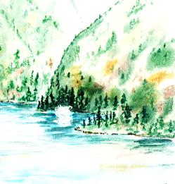
Fig. 2. Watercolor sketch of the vorte
Fig. 2. Watercolour
sketch of small rare whirlwind seen on
Lac la Fourche,
18˚ 23˚ 25˚
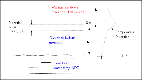
Figure 3. Temperature
profile over cool lake surface
Cool water temp. 18˚C
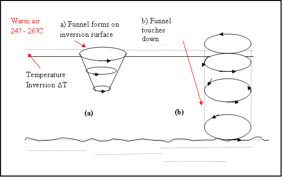
Fig. 4 Schematic cross section ( a) Incipient whirlwind (b) The fully formed vortex.
The first conclusion of the study was (1) that, if the
vortex were an atmospheric heat engine, then
the heat source must be the warm air just above the temperature inversion at a height
of about a meter or so above the surface of the lake; (2) the heat
difference ΔT between a heat source in the warm air above
the inversion and the heat sink in the core of the cortex at the lake surface
could not be more than the temperature difference between water temperature and
air temperature which was at most about
7˚C, and more likely was only about half that value or 3.5˚C. In that case the resulting winds from Table 1
would be only 9 to 18.5 m/s, far below the 30 to 35 m/s observed.. We
cannot therefore explain this cool-lake whirlwind (CLW) as a heat engine transforming heat
energy into wind speed.
Even adding in heat of condensation from the formation of the column of mist in the vortex core will not make up the difference. The liquid water content of clouds ranges from 0.2gr. to over 3 grams per m3 . Each gram condensed out released 680 calories of heat. Therefore the temperature rise of the air into which the vapor condenses can be calculated from the heat Q released into the air per gram of water vapour condensed to liquid which is Q = 586 calories /gm. ( or 2.454 Joules ).
In Table 3 the temperature rise in one cubic meter of air by an injection of 586 calories of heat ( 2.454 Joules) is calculated from Q = mass x ΔT x specific heat of air. Thus, ΔT = Q / m x 0.244 = 586 / 1000 x 0.244 = 2.4 degrees per gram of water vapour condensed to liquid cloud droplet form. Neglecting several small corrections, such as for ventilation and so on, we get the following approximate temperature rises to be expected from condensation: :
Table 3
Approximate
Temperature Rise ΔT Expected from
Cloud
Condensation in a Vortex Core
Condensed Liquid water Temperature rise (ΔT)/m3
0.5 g/m3 1.2 C
1 2.4 C
Therefore, condensation of the water vapour in the inflow of moist air at the surface of the lake into the vortex would apparently add only 1 to 2.4 ˚C to the heat input, still much too low to explain winds estimatd ate 30 to 35 m/s.
Finally, we cannot expect the inflowing air at the surface of the lake to add heat, as it does with tornadoes at their touching down, since, in this case , the lake water is cool and the air over it, while moist, would still be cool. So, any inflow of surface air would be cool instead of warm and would reduce the vortex winds instead of increasing them.. It appears then that the heat engine model fails to explain the sudden violence of these tiny rare vortices and that some other mechanism must be sought.
Turning from the heat engine model, we now, instead, examine an isentropic transformation relating heat energy in the form of temperature differences ΔT to the kinetic energy ( ½ mV2) and flow velocity V. Since the transformation is isentropic, no work is done, the thermodynamic efficiency restriction of Equation 1 does not apply, and much larger velocities emerge.
6.0
An Alternative Explanation: The Vortex as an Isentropic, Adiabatic Flow Transformation.
The isentropic transformations of energy from heat into flow velocity with no work done, is given by [6]
V = n1/2 co [1 − T/To]1/2 = n1/2 co [ ΔT/To]1/2 (2)
.
This is derived as follows; We start with the kinematic energy equation in terms of wave speed c, static wave speed co, temperature T, flow velocity V, and n, the number of ways the energy of the air is divided. ( n also equals 2/ (k − 1) where k is the ratio of specific heats cp/cv. and has the value of 1.4 for air.) As is usual in flow theory, we consider unit mass of fluid so that m (= 1) does not appear explicitly in the equation.
c2 = co2 − V2 /n
c2/co2 = 1 − V2 / nco2
If we now further restrict the adiabatic case to isentropic flow, we can apply the usual isentropic relations
c2/co2 =( p/po)2/n+2 = ( ρ/ ρo)2/n = T/To and so
T/To = 1 − V2 /n co2 , whence we have Eqn. 2 above
V = n1/2 co
[1 − T/To]1/2
= n1/2 co [ ΔT/To]1/2
which gives the relationship between flow velocity V and the temperature drop ΔT
Table 4 gives the computed values of V for a range of temperature drop ΔT ,calculated from Equation 2, and taking n = 5, co = 330 m/s, and To as 293 ˚K.
Table 4
Flow Velocity Versus Temperature Change in Isentropic Adiabatic Flow
V = n1/2 co [ΔT/To]1/2
For To = 293 K ( 20C), n = 5 , co = 330 mps
ΔT T ΔT/To V
-----------------------------------------------------------------------------
m/s mph
0.5 292.5
0.0017
30.4 68.1
1 292
0.0034
43 96.2
2 291 0.0068 61 136.4
3 290 0.01 74.7 167
4 289 0.014 86.2 192.9
5 288 0.017 96.4 215.6
10 283 0.034 136 304.2
15 278 0.051 167 373.4
20 273 0.068 192.8 431.2
40 253 0.137 273 610.7
Note 1: Values in blue are for the observed cool lake vortex wind speeds and corresponding temperature differences. Values in red are for the maximum observed tornado wind speeds [7,16].
It is apparent that isentropic flow velocity
transformations can account for the magnitude of the winds arising in the CLW from very small
temperature differences in the inversion over the cool lake surface. Table 4 shows that even a temperature
differential at the inversion level of only 0.5˚C transforms or corresponds to a flow velocity of 30.4m/s or
68.1mph, while a 1˚C temperature
differential would produce a wind speed
of 43 m/s ( 96.2mph). Therefore we can now explain the Lac de la
Fourche observed wind speeds of 30 to 35 m/s from the temperature difference in
the temperature inversion over the lake
with an isentropic energy transformation.
We must note, however, that there remain certain difficulties with the proposed isentropic explanation. Strictly speaking, such a transformation requires that there be no heat input or output. This would seem to rule out latent heat of condensation being involved, and yet the visible condensation funnel is an essential fact of these vortices. Again, there is the fact that surface temperature inversions over cool waters are very common in the atmosphere, yet these violent little vortices are very rare. The general rule is that atmospheric processes are non-isentropic, involving radiation heating or cooling, condensation and evaporation, and non-isentropic turbulent exchange all of which act to overmaster the isentropic process.
However, the sudden appearance of these rare violent vortices is a fact, and the isentropic process can explain their sudden appearance and their wind speeds. Their subsequent evolution, of course, almost certainly would appear to be either non-isentropic or only quasi-isentropic..
Finally, if this mechanism acts at one temperature inversion
in the atmosphere ( CLW), it must also be able to act at other similar
atmospheric inversions, large or small , and so we may also have also explained
the early stages of tornados and waterspouts
as well. A temperature
differential of only 10˚ C--- easily reached in the lower atmosphere-- will account for the maximum observed
wind speeds in tornadoes (Table 4).
This would be an important step towards a complete
explanation.
7. A possible new insight into tornado formation at temperatures inversions
aloft
The initial source of the tornado funnel in the lower portion of the thunderstorm storm is now addressed.
It has been reported that many tornado funnels originate in association with a microburst or downburst of cool air that takes place under a storm cloud as a shaft of falling rain emerges from the storm cloud. [ 14, 15, 16,17]. This rain shaft cools the air by evaporation and so a surge of cooler and denser air flows out from beneath the storm cloud somewhat like a miniature shallow cold front outflow ( Fig. 3).
Here we have a parallel
physical counterpart to the surface inversion of temperature found in
our “cool lake whirlwind ’ ( CLW) , except that now the inversion is several
thousand feet above ground at the top of the cool air dome (Fig. 3). . We
therefore propose that, just as the CLW vortex was generated in the surface inversion over the lake,,
so tornado vortices may also form at the cold dome inversion generated by
falling rain from the thunderstorm cloud (Fig. 3).
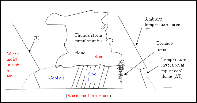
Figure. 3 Tornado
forming in temperature inversion at top of precipitation-cooled air dome beneath
thunderstorm cloud
Once the tornado funnel touches the ground, the infiltration of warm surface air would provide a second source of heat energy. Similar considerations would apply to the case of waterspouts.
In this proposed model there are two key phases, first, the initial phase of the tornado prior to touchdown is not a heat engine but is an isentropic or quasi-isentropic energy transformation process (Eqn. 2), and, second, at tornado funnel touchdown a change in the mechanism from isentropic over to the non-isentropic heat engine process (Eqn. 1) begins.
We must point out at this point that the above new model, while it offers a solution to one key problem of the thermodynamics of atmospheric vortices, is still only one aspects of the complete picture of tornado dynamics. The new element is a proposed solution to one current problem in all there vortices, namely the source of the initial high wind speeds. There are, of course, many different kinds of atmospheric vortices, gust front vortices, fair weather cumulus tornados etc .which do not involve inversions although all involve temperature differences. The new model also does not address the source of the initial vorticity required to start the vortex motion; this has been quite exhaustively studied and indeed appears to now be reasonably well understood [3]. The new isentropic energy transformation model proposed here, then, while it appears to solve one key problem, still requires being evaluated and integrated into the other detailed knowledge on the structure and dynamics of these great storms If validated, it will obviously supply a key piece to the puzzle.
8. Insights into Potential Tornado Modification or ‘ Control’
?
The
new model points to the storm cloud’s temperature inversion area as the site of
tornado funnel formation. Here an isentropic process takes place. Anything that
interferes with the isentropic process at the inversion site would
theoretically impede tornado formation. It would therefore seem useful to study
this carefully from the point of view of physical and chemical changes which
might permit useful intervention strategies.
Again,
if condensation of water vapour does supply usable heat to the isentropic
vortex without disruption, then
condensation inhibitors might be of interest
to tornado suppression strategies, provided that they can be employed on
a sufficiently small or local scale.
In this latter regard,
investigations into ice and condensation nucleators some years ago [18,19,20}] revealed that naturally
occurring organic vapours, such as terpenes and other essential oil vapours
released naturally from vegetation are very active in condensation processes.
Ammonia vapour, on the other hand, was
found to be a powerful suppressor of condensation and of cloud droplet
stability, while surfactants, such as aliphatic alcohols, and especially octal
alcohol (octanol) powerfully aided
condensation and stabilized cloud droplets against evaporation. Ammonia vapour
in milligram amounts produced observable effects of disrupting cloud growth
and stability at distances of a kilometer or so downwind from the ground
based points of release.
Examination
of data on tornado occurrence and time trends of their frequency with respect
to concurrent changes in agricultural crop types, agricultural practices, and
environmental interventions such as pollution, might prove of interest.
9. Conclusions
Analysis of the very simple, cool
lake whirlwind (CLW), points solely to an isentropic thermodynamic process as
the cause.
The
initial stages of tornadoes and waterspouts can not be described as being those
of a thermodynamic or heat engine; this is because the initial atmospheric
temperature differences available are much
too small and the observed initial wind speeds are far too high.
An
isentropic energy transformation model does fit the initial temperature and
wind speed data of tornadoes and waterspouts; however, any ordinary inflow of heat would contradict the
isentropic process, so that a purely internal energy transformation
must also be postulated. This also requires an internal isentropic flow for any latent heat released from
condensation of water vapour in the incipient tornado funnel.
We therefore conclude that the
isentropic process does play a key role in tornado-genesis, but that the
details of the flow mechanism remain to be understood.
References
1. Vonnegut, Bernard, Electrical Theory of Tornadoes. J. of Geophysical Re., 65, 1, pp 203 -212, Jan. 1966.
2. Colgate, Sterling A., Tornadoes: Mechanism and Control. Science 157, 1431 -1434, 22 Sept. 1967.
3. The Tornado: Its Structure, Dynamics, Prediction and Hazards. Church, C., Burgess, D., Doswell, C., Davies-Jones, R., (eds.). AGU Monograph 79, American Geophysical Union. Washington, D.C. 1993.
4. Lamb, Sir Horace. Hydrodynamics. Dover Publications Inc. New York, 1931.
5. Prandtl, L. and O. G. Tietjens, Applied Hydro- and Aeromechanics, Dover Publications Inc., New York, 1957.
6. Shapiro, A.H., The Dynamics and Thermodynamics of Compressible Fluid Flow. 2 Vols., Wiley and Sons, New York, N.Y. 1953.
7. Lewellen,
W.S., Tornado Vortex Theory: AGU Monograph 79, (Ref. 3 above ) pp
19-39 , 1993.
8. Rankine, W. J., A Manual of Applied Mechanics, , Charles Griffin, London, 1882.
9. Brunt, David, Physical and Dynamical Meteorology. Cambridge University Press, 1941.
10. Abdullah, A.J., Some Aspects of the Dynamics of Tornadoes. Monthly Weather Review, 83, 4, pp. 83-94, April 1955.
11. Golden, J, H., The life-cycle of Florida Keys’ waterspouts, J. Appl. Meteorol., 13 667-692 and 693-709, 1974.
12. Idso, Sherwood, B., Tornado or Dust Devil: The Enigma of Desert Whirlwinds. American Scientist, 62, 530-541, Sept. – Oct. 1974.
13. Rossman, Fritz O., Waterspouts and Tornadoes, Weather, pp. 104-106, March 1956. Royal Meteorol. Soc., London [ Monthly Weather Review 48, p.351 1920 ( re the May 16, 1920, re Observations on Lake Newcombe, Adirondack Mountains , N.Y.].
14. Purdom, James, F.W.,
Satellite Observations of Tornado
Thunderstorms. AGU Monograph 79, (Ref. 3 above) pp 265-274. 1993.
15.
Fujita, T.T., and B.E. Smith, Aerial Survey and Photography of Tornadoes and
Microburst Damage. AGU Monograph 79, (
Ref. 3 above) pp 479 – 493, 1993.
16.
Bluestein, Howard A. and Joseph H. Golden, A Review of Tornado Observations. AGU Monograph 79, ( Ref. 3 above) pp. 319 -352. 1993.
17.
Davies-Jones, Robert and Harold Brooks, Mesocyclogenesis From a Theoretical
Perspective. AGU Monograph 79, ( Ref. 3
above) pp. 105 – 114. 1993.
18. B. A. Power and
R.F. Power, Some Amino Acids as Ice Nucleators. Nature,
Vol. 184, 1170. 1962.
19. -------------------------------------, Vanillin, cis- Terpin and cis- Terpin Hydrate
as Ice Nucleators. Science. Vol. 148, 1088, 21 May, 1965.
20.---------------------------------------, Work on
condensation nucleation and especially on organic nucleators, unfortunately had
to be terminated without publication.
![]() Copyright 2008. Bernard A. Power, Consulting Meteorologist (
ret.)
Copyright 2008. Bernard A. Power, Consulting Meteorologist (
ret.)